Back in December 2024, Niantic posted about a large geospacial model they were building using data from Pokémon Go.

That led to a lot of online talk, with takes ranging from:

  • Well yeah, that’s what we figured they were doing with the “Scan a Pokéstop to build better AR models” feature.
    to
  • Watch out! Niantic is building a global AR model using every image that passes in front of your phone’s camera!

I was in the “of course that’s what it’s for” camp. When the game rolled out the Pokéstop scanning feature a few years earlier, it seemed obvious that it was training 3D machine vision, like how all the “pick the squares with bicycles” CAPTCHAs are obviously training for self-driving cars. I figured there was a good chance someone would use it for some harmful purpose or another, probably surveillance, so I skipped those tasks.

Anyway, after a week or so, Niantic updated the article to clarify* that it was using the deliberate Pokéstop scans in public places for Pokémon Playground, not any of the other AR features like taking a photo of your buddy in the kitchen.

This made sense, because if they were using that data, it would have eventually gotten better at placing a Pokémon in my kitchen. (The floor’s a grid. You’d think that would help, but noooo….)

Drones (And not just Beedrils or Combees)

Those scans are back in the news, because as DroneXL reports, that geospatial model is being used for camera-based drone navigation.

Including military drones.

Because of course everything has to be weaponized. Allegedly even Pixar’s RenderMan.

Admittedly, GPS itself started as a military technology long before it became civilian infrastructure. Military and civilian tech really do just have a revolving door between them, don’t they?

Training Data

Among other sources, DroneXL cites a Dutch-language article at Trouw, who asked the defense contractor (Vantor) directly whether it uses Pokémon Go data: Vantor initially said no, but later walked back any guarantee. Niantic Spatial, however, has stated that the Pokéstop scans were used to train an “early version” of their model. That means the data (or weights produced from it) is still in there, just blended so much by training process that it can’t be identified anymore.

Kind of like you probably couldn’t confirm my old blog posts are in the training data for an LLM by looking at the LLM weights, but you can find pages from hyperborea.org in Common Crawl data, and assume any model trained on Common Crawl still has it in there somewhere.

Maybe scans made since Scopely (US-based, Saudi owned) bought Niantic’s gaming division last year haven’t gone into the map built by Niantic Spatial (still independent), so Vantor technically isn’t using current player data. Or maybe Niantic Games continued passing scans along to Niantic Spatial for a while, under the separate TOS, and Vantor’s spokesperson just hadn’t made the connection.

Quietly Dropped

Curiously, the Pokéstop scanning task I’d left in my list for years just disappeared a few days ago.

At first I deleted the tasks as I got them, but every time I scanned an eligible stop it would add a new one if I didn’t have one in my list. So after a while I just left one there and ignored it like an ad banner.

It turns out Pokémon Go discontinued the features on June 2, just three days before the Trouw article was published. (New tasks stopped appearing that day, and it took a few days for old tasks to disappear.)

Coincidence? Maybe. But the timing’s certainly suspicious.

Notes

* Before Niantic published their update, I e-mailed them asking for clarification. It took them over a month, but they did eventually reply:

Hi Trainer, we appreciate your patience. Thanks for your questions about AR Mode and our Privacy Policy. I’ve shared some additional information below:

For Pokémon GO, only AR scans from the PokéStop Scanning feature will contribute to the development of the Large Geospatial Model. As noted in the PokéStop Scanning Help Article (https://niantic.helpshift.com/hc/en/6-pokemon-go/faq/2519-scanning-a-pokestop/): information gathered during PokéStop Scanning allows Niantic to generate accurate, dynamic 3-D maps of real-world objects and their relative locations, and help devices understand the surroundings in AR real-time. As noted in the Editor’s note to the blog post, merely playing the game does not train an AI model.

When using AR or AR+ mode, we do not store your photos on our servers. For PokéStop Scanning, once a PokéStop scan is voluntarily uploaded, the video recording and associated camera data is retained on our servers in accordance with our data retention policies. For more information please see our Privacy Policy (https://nianticlabs.com/privacy).

Between Google trying to bury its search under an “AI” chat and me moving most most of my website over to a new domain, I’ve been checking to see how well-indexed the old and new pages are at various search engines.

“Marineland of the Pacific” seemed to be a good phrase to test. Marginalia Search still has the old location for my Remembering Marineland (or not) post, but that search also turned up a page with scans of a Marineland ad flyer from 1962.

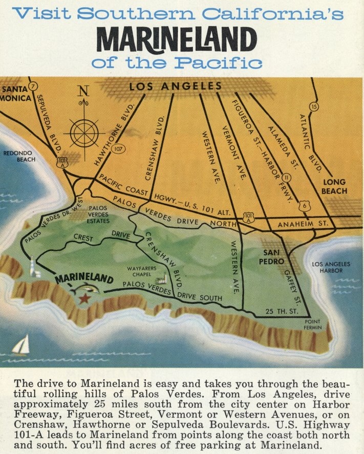
As someone who’s spent a lot more time hiking the Palos Verdes Peninsula than visiting an ocean theme park that closed when I was a child (not to mention way too much time updating OpenStreetMap), I was immediately drawn to the map…which strangely enough, shows Crenshaw Boulevard running over the hill, down through the Portuguese Bend landslide and connecting to Palos Verdes Drive South along the coast, just east of Wayfarer’s Chapel.

Simplified map of the Palos Verdes Peninsula showing Palos Verdes Drive around the peninsula, Marineland on one of the promonitories, major roads connecting to Los Angeles (Sepulveda, Hawthorne, Crenshaw, Western), and roads going *over* the hill including Hawthorne, Crest, and...wait, Crenshaw?

Wait, did Crenshaw actually connect sometime in the past? If so, how?

Today, Crenshaw runs up to the top of the hill and stops just past Crest Road, at Del Cerro Park. A dirt road continues past a locked gate, narrowing to a switchbacked path through the Portuguese Bend Nature Reserve. A landslide below it has been moving slowly for decades, preventing much in the way of construction on the land. Some people bought land and built houses on adjustable stilts so they could level the house every few months.

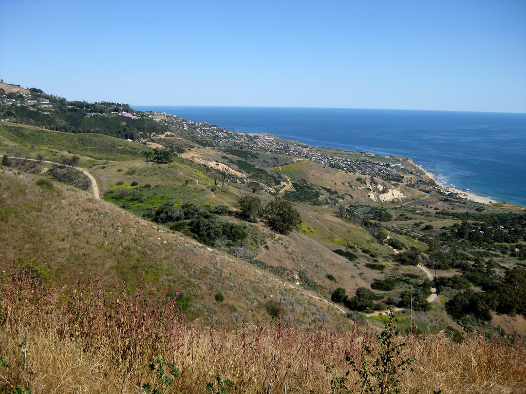
The first time I checked out the view from Del Cerro back in 2011, I took this photo of the area to the east, where Crenshaw appears on that map.

Looking out along a hillside sloping down to the ocean. Most of it is dry chaparral, with some clusters of darker trees, and a jumbled suburban neighborhood off in the distance as it levels out near the base. A dirt road snakes its way around the curves.

Over the last few years the land has been sliding faster, and a lot of the area has been closed for safety. Wayfarer’s Chapel has been dismantled to prevent it from flat out collapsing.

It’s no longer possible to connect Crenshaw to the coast.

But had it connected in the past, and been wiped out by the landslide? I went looking for the history, and found some articles that answered my question. I must have read this 2023 LA Times article when it was published, which means I’d forgotten a key detail about Crenshaw Boulevard’s relation to the landslide:

It caused it.

Crenshaw never connected to the coast. An extension was planned, and initial construction reactivated an ancient landslide in 1956, as crews moved enough dirt around to shift the underlying structure out of balance. At the time, the Portuguese Bend section hadn’t moved in roughly 4,800 years. In the 70 years since, it hasn’t really stopped.

If the map was drawn when the park was new, it would have been reasonable to assume that the road would be completed soon enough, and draw it in early. (“It’s finished on the map!”) But the scan shows a 1962 copyright date at the bottom. That’s six years into the landslide, more than enough time to realize the road was never going to be completed and paint over it for the latest printing. That makes me wonder why they hadn’t fixed it by then.

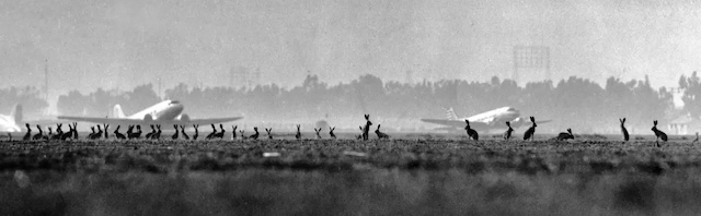
Line of rabbits along the ground, silhouetted against some old-looking airplanes and trees in the distance.

When wild jackrabbits roamed the fields of LAX. (Los Angeles Times)*

From time to time passengers in giant air liners are amused when giant jacks race the plane on take-off. Until now, none of the rabbits has left the ground.

I’m reminded of all the rabbits we used to see near UCI in the 90s, especially out in the housing complexes on the edge. A lot of that open space has been filled in since then. I’m told they were still all over the place as of 2010, but I can’t remember seeing any the last few times I was on campus. Though several of those were Wayzgoose, which I’m sure would have most of the rabbits hiding in their burrows, waiting for all the people to leave so they can see what food they might have dropped. Then again, I don’t remember noticing squirrels at the time either, and I’ve seen squirrels walk up to me and pose like Oliver Twist asking for more soup.

Anyway, the rabbits at LAX were eventually wiped out by foxes, who have since disappeared from the airport as well.

About Those Foxes…

But the foxes are still around! Just not on the runways. LAist ran a story about the local population of red foxes on the Palos Verdes Peninsula just last month. The LA Natural History Museum has an article on the species’ history in the area, from being imported and farmed for hunting and fur in the early 20th century, to going feral, to a population boom in the 1980s.

The red fox coexists with the native gray fox on the peninsula, but coyotes will kill them, and the current population is believed to be fairly low.

Could be worse, though. The Channel Island fox almost went extinct through a Rube Goldberg food chain of events. SFGate reported on their plight and rebound (on the same day LAist published the piece on red foxes, oddly enough!) due to the feral pigs (way more than 30-40) left over from the islands’ farming days. The pigs not only overran the islands’ vegetation — it was basically trees and grass and nothing in between for years — but they attracted predatory birds from the mainland who, once they were in the area, went after the smaller, easier prey: the foxes. By 2004, there were only a dozen on each of two islands.

The National Park Service hired an outfit to hunt down the feral pigs over the next few years. The islands’ vegetation — and the foxes –rebounded. By 2016, the island fox was removed from the endangered species list entirely.

*Photo credit: Art Rogers, originally published in the Dec. 2, 1946, edition of Life magazine and later in the Aug. 4, 2011 LA Times.

Expanded from a Mastodon post I wrote back when the LA Times highlighted the LAX rabbits in a “From the archives…” story in 2017.

A while back, I mentioned one of the exhibits I remembered from a childhood visit to the Los Angeles Museum of Science and Industry (now the California Science Center) in the 1980s:

…a multi-screen cartoon about energy sources and engine types called “The Water Engine.” (Each screen has a character talking up internal combustion, flywheels, mag-lev, electric, etc. I still quote the Peter Lorre-inspired fuel-cell scientist saying “And then…we burn the hydrogen!”)

At the end, the scientist tries repeatedly to ignite the hydrogen while everyone else watches nervously, then starts hiding behind obstacles or off-screen before the inevitable explosion bursts across all the screens. Then they all climb out of their hiding spots and agree that this would be really cool once the kinks are worked out, but it’s not there yet.

Brooke brought it up on Mastodon last month and I decided to go looking for it again. In 2017 there was nothing I found to show it even existed. In 2024 the only thing she could find at first was…my blog post from 2017. Which I’d forgotten writing. 🤦‍♂️ I kept looking, and found a brief note that it was later shown at EPCOT, with a link to a long-dead page that had been archived in 2002 containing some extremely tiny screenshots!

9 tiny cartoon screens in a grid: You can just barely make out a cowboy, a child with a large tricycle-like assembly, a football coach, a miner with a hard hat, some old, yellowed parchment with a sketch on it, someone carrying an axle with wheels, a large lab flask filled with water, an old man holding up a picture of a horse, and someone in a superhero outfit standing on a row of horseshoe magnets.
Rescued from a long-dead web page via the Internet Archive.

Adding EPCOT to my search eventually turned up an extremely sparse IMDB entry and…*drumroll please* someone’s home camcorder video of the whole presentation!

It does exist! It wasn’t a shared hallucination! The fuel cell scientist (who extracts the hydrogen from water, hence the title) does sound like Peter Lorre! He does indeed say the line that my family still quotes decades later! And it does indeed explode across the whole display!

Me, driving a smallish gas-fueled car in the 2000s: Wow, gas has gotten expensive these days, but at least I’m not spending too much per tank.

Me, driving a hybrid car in the 2010s: Yeah, gas is still expensive, but I’m still not spending too much per tank, and I think I’m filling it less often than I used to.

Me, driving a plug-in hybrid to the grocery store and back during the first year of the pandemic: I have no idea how much gas costs. I haven’t filled the tank since the before times. I hope the gas engine still works.

Me, driving the same plug-in hybrid normally during the 2020s: Oh yeah, gas is kinda expensive. At least I don’t have to fill up the tank very often, and it’s not too much when I do.

Me, driving a rented gas-fueled SUV to the next county and back once: WTF I’M SPENDING HOW MUCH TO FILL UP THIS TANK!?!?!?

You know the old joke about “drugs would be cheaper?”

The Adderal shortage has gotten so bad that Mexican pharmacies are selling counterfeit pills to tourists…made of meth.

(I should clarify that it’s the counterfeit pills, not the tourists that are made of meth.)

Update: Sadly, science fiction author Terry Bisson (who wrote “They’re Made of Meat” among many other stories) died a few weeks later.

»All pages site-wide with this tag